


Massive fire consumes West Greenland
For just over the last week, a number of wildfires have been burning in the Greenland. The largest of which has so far burned roughly 3000 acres and has seen smoke billowing into the sky.
The main blaze is in a remote area, located about 90 miles northeast of the town of Sisimiut, which has a population of approximately 5,600 people. There’s also a second, smaller fire burning in the vicinity.
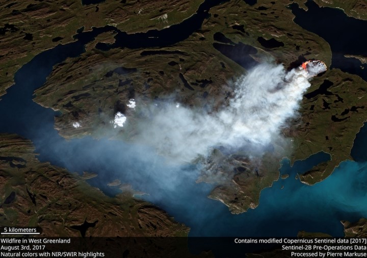
Professor Stef Lhermitte (@StefLhermitte) , of Delft University in the Netherlands, reported that the largest blaze ever recorded had broken out on the island. Prof Lhermitte tweeted; : “Wildfires have occurred in the past over Greenland but 2017 is exceptional in number of active fire detections.”
The NASA Earth Observatory describes the fires as an “unusual event”.
“Satellites first detected evidence of the fire on July 31, 2017. The Moderate Resolution Imaging Spectroradiometer (MODIS) and Visible Infrared Imaging Radiometer Suite Suomi NPP collected daily images of smoke streaming from the fire over the next week.
“The Operational Land Imager (OLI) on Landsat 8 captured this more detailed image of the fire on August 3, 2017.”

Due to the fires and related smoke being released, the Greenland police are warning hunters and visitors to stay away.
We are incredibly sad to see such a fire burning in what is a beautiful but remote location.
The size of the wildfire is small compared to ones that have hit the US and Canada, but it is large for the mostly icy country of Greenland. Experts have not yet determined what caused the fires or exactly how long they will last, but multiple satellites are keeping watch.
With little rainfall expected in the near future, the fires could keep burning for days to weeks.
Greenland’s vast ice sheet, which could raise global sea levels by six metres, lost a trillion tonnes of ice between 2011 and 2014, according to one recent study which found the rate of melting had tripled.
We hope the fires don’t burn for too much longer.